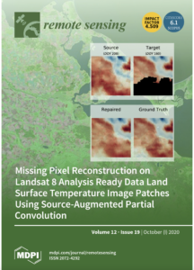
 A recent publication by CSU Natural Resource Ecology Laboratory (NREL) scientists Maosi Chen and coauthors Zhibin Sun, Benjamin H. Newell, Chelsea A. Corr and Wei Gao called, “Missing Pixel Reconstruction on Landsat 8 Analysis Ready Data Land Surface Temperature Image Patches Using Source-Augmented Partial Convolution” was selected to appear on the cover of the October 2020 issue of Remote Sensing and belongs to the Special Issue Towards Practical Application of Artificial Intelligence in Remote Sensing.
Missing pixels in satellite images can be caused by poor atmospheric conditions like thick cloud cover or satellite sensor malfunctioning, but poses a common problem that can affect image analysis and applications. An area of active remote sensing research is attempting to develop algorithms and models in order to reconstruct missing pixels in satellite images using other, complete imagery.
The team chose source and target images from Landsat 8 Analysis Ready Data (ARD) Land Surface Temperature product to develop their models. The model proposed in the study achieves better reconstruction performance than standard deep learning models because it utilizes the improved partial convolution operation (which adjusts the output for missing pixels) and accommodates the source image into the framework.
This study uses a data-driven, deep learning approach, which learns the “rules” of filling gaps from a large amount of training samples and requires no prior human knowledge of these “rules”. With sufficient relevant data, this approach can then be applied to other satellite image analysis tasks such as enhancing resolution, data fusion and object recognition.
“We deeply appreciate the recognition of our work by the remote sensing journal.” said lead author Maosi Chen. “This improves our confidence in exploring new deep learning architectures and applying them on actual research problems.”
The authors are affiliated with the United States Department of Agriculture UV-B Monitoring and Research Program through NREL, as well as the CSU Geospatial Centroid.