
The number of people living in areas at risk to the effects of wildland fire increased by nearly 50 percent from 2012 to 2017, based on new Colorado Wildfire Risk Assessment data released this week by the Colorado State Forest Service.
As of 2017, approximately 2.9 million people were living in Colorado’s wildland-urban interface — the area where human improvements are built close to, or within, natural terrain and flammable vegetation — compared to 2 million people just five years earlier. The new figure represents around half of the state’s total population.
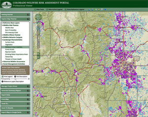
These data are included in updates to the Colorado Wildfire Risk Assessment Portal, or CO-WRAP, an online mapping tool that helps community leaders, professional planners and interested citizens determine wildfire risk and where forest management actions can achieve the greatest impact to reduce risk.
The Colorado State Forest Service recently completed an update to the Colorado Wildfire Risk Assessment based on new housing, population, vegetative fuels, weather and other data. This is the first major update to the dataset since 2013.
“With the continued increase in Colorado’s wildland-urban interface population, it’s critical for landowners and communities to take actions to reduce their risk and address forest health concerns,” said Mike Lester, state forester and Colorado State Forest Service director.
“The Colorado State Forest Service provides necessary resources to assist forest landowners and wildland-urban interface communities to make their forests healthier and safer,” he added.
Web-based portal provides wildfire risk assessment
CO-WRAP was launched in 2013 and provides access to statewide wildfire risk assessment information. The site allows users to generate maps and download data and reports that describe defined project areas, such as communities or watersheds. The information in the portal is based on geographic information system (GIS) data layers that allow users to view such themes as potential fire intensity, historic fire occurrence and values at risk from wildfire.
Amanda West, Colorado State Forest Service science information manager, said that the increased population in the wildland-urban interface is due not only to more people moving into these areas, but also to better, more refined data and ongoing changes in land use and vegetation patterns.
West said that the largest increases in population growth within the interface are in areas where agricultural lands are being converted to grasslands and subdivisions. Although these areas are considered in a low-risk category by the assessment, they are still at a higher risk for wildfire than more urban areas.
The portal features two levels of access: one for community leaders, planning and forestry professionals, and one for interested citizens.
The professional view offers access to data and tools for use in creating fire protection or forest stewardship plans, supporting Community Wildfire Protection Plans or identifying priority fuels treatment areas. It also allows users to generate detailed risk summary reports for customized land areas such as neighborhoods, fire protection districts or counties.
New dataset includes burn probability modeling
“CO-WRAP offers a consistent dataset across Colorado to use for hazard mitigation planning,” said Kristin Garrison, fire, fuels and watersheds manager at the Colorado State Forest Service. “Whether you are focusing on the community level or watershed level, it provides baseline data for planning efforts.”
Garrison said that a new feature for 2018 is a statewide “burn probability” layer produced using an advanced GIS tool for modeling wildfire behavior and spread, based on millions of wildfire simulations. The revised web portal focuses not only on the probability and potential intensity of wildfire, but also the values at risk from the negative effects of wildfire including homes, drinking water supplies and forest assets.
West cautioned that CO-WRAP should not be used to determine parcel-level risk to individual homes, as it is instead scaled to address risk at the community or watershed level. It should also not be used to predict current fire danger.
“This is not a source for real-time fire risks or restrictions,” she said.